Well, well, well, it’s only taken 25 years since I got involved in the world of out of place artifacts, but it’s finally happened. A mainstream archaeologist has written a 2024 paper where he concluded, although somewhat tepidly, an inscribed stone I have scientifically examined was authentic. While it really shouldn’t be a big deal, it actually is a big step in the right direction. David Mather, a National Register Archaeologist with the Minnesota State Historic Preservation Office wrote a paper about the Du Luth Stone concluding it was “More likely authentic than not.” Mather went on to say in his closing remarks, “On its own, I believe that the Du Luth Stone is likely eligible for the National Register of Historic Places as an object.” I couldn’t agree more.
This is important, and I congratulate David for having the courage to ultimately draw the correct conclusion. That said, he couldn’t help himself by including criticism of me and archaeology’s favorite whipping boy the Kensington Ruen Stone. He and his colleagues should know better than to trot out the tired and completely unsupported assertion that the artifact is a hoax. I have published numerous papers and books with voluminous conclusive evidence, in multiple disciplines (geology, words, runes, dialect, grammar, medieval Easter Table dating, medieval and late 19th Century history), the artifact is, in fact, authentic.
Instead of even mentioning one piece of evidence to support his assertion and belief, he resorts to name-calling labeling me a “pseudoarcheologist.” I was the one who took Mather to see the artifact in the first place and instead of taking the research I shared seriously; he roundly dismissed it without any intellectual curiosity or serious consideration. This is the typical of my experience with archaeologists who are incapable of thinking outside of their historical paradigm box. It’s disappointing and frankly, is a disservice to the public who pay their salaries.
I’m not going to waste the reader’s time arguing why I am right, and Mather is wrong when it comes the KRS and the Templars who carved and it along the north-south continental divide as a land claim. He, like many other archaeologists I’ve interacted with seem incapable of considering factual evidence with an open mind. It should be noted Mather confirms the Du Luth Stone, like the Kensington Rune Stone, is located along an important watershed divide. What I have done publicly in my response the Duluth Herald article that was recently published: Duluth News Article , and will do here again, is issue a challenge to Mather to join me in a public debate about the authenticity of the Kensington Rune Stone (two words). I can assure you he will decline, for when he dives into the “evidence” to support his “belief” he will find there is zero factual evidence to support a hoax. Either that, or he won’t respond at all. The lack of a response will tell us he also knows there is no evidence to support his belief, and how could there be since it is 100% a genuine medieval artifact and vitally important to not only Minnesota history, but the world history.
I’m ready when you are David…
Here is the paper I wrote about the Du Luth Stone back in 2009:
The Du Luth Stone Investigation
By Scott F. Wolter
December 21, 2009
Introduction
This report presents the results of field and laboratory work performed on an inscription carved on a glacial erratic boulder comprised of Hinckley Sandstone. The artifact was discovered near Askov, Minnesota.
Background Information
Daniel Greysolon Sieur du Luth (1636-1710), was a native of St. Germain-en-Layes, a suburb of Paris, France. According to available records, Du Luth’s first visit to New France (North America) was prior to 1674 where he joined several relatives who preceded him to old Montreal. In 1678, he resolved to explore the land of the Sioux Indians and began his journey by navigating the length of Lake Superior. From there he made his way through a tangle of rivers and lakes to discover the headwaters of the Mississippi where he planted the coat of arms of the French crown in the heart of Sioux territory.
Du Luth negotiated a strong and profitable alliance with the Sioux whose territory abounded with furs including beaver. He then visited the area of northwest Lake Superior where he was successful in negotiating peace and diverting the rich northern fur trade from routes leading to the English in Hudson Bay to those leading to the Great Lakes and the Ottawa (Wisconsin Historical Society, Document AJ-054, pages 325-328).
It was during his trek to the Mille Lacs Lake area in 1679 that he passed through the Askov area. It is possible the carving was made as part of marking a trail and/or claiming land for France.

Map of the route Daniel Greysolon Sieur Du Luth traveled through Lake Superior into Minnesota, Isle Royale and Wisconsin before returning to Montreal in 1680. The red circle indicates the area where the Du Luth Stone is located near Askov, Minnesota. (Map redrawn by Dan Wiemer from Blegen, 1975, page 47)
Site Visits
On October 16, 2009, a site visit was conducted where myself and retired professor of geology at the University of Minnesota-Duluth, Dr. Charles L. Matsch, were led to a parcel of land owned by John and Janelle Abraham, by Mr. John Ecklund, and his son Eric, to examine the inscribed boulder.
During this visit several aspects of the boulder and the inscription were documented. Numerous photographs were taken using both a 35mm digital camera and a Canon portable microscope. A hand sample of the Hinckley Sandstone was obtained from another nearby glacial boulder was also collected for laboratory analysis.
I visited the site again on November 21, 2009, with archaeologist Dave Mather, with the Minnesota State Historic Preservation Office. On this visit, we were escorted to the site by landowners John and Janelle Abraham.
After the site visit Dave Mather and I examined a large monument of Hinckley Sandstone in a park within the city limits of Askov. The monument was reported erected in 1927 (Arla Budd, 2009) and both macro and microscopic photographs were taken for relative-age weathering studies. We then visited the Askov cemetery where we located two monuments comprised of Hinckley Sandstone, dated 1927 and 2008, where additional data was collected for weathering studies.
Petrographic Analysis
On October 18, 2009, and subsequent dates, the sandstone hand sample collected was reviewed under both reflected and polarized light in accordance with ASTM: C 295 procedures. Thin section preparation and review was performed by Adam Brewer on November 23, and subsequent dates.
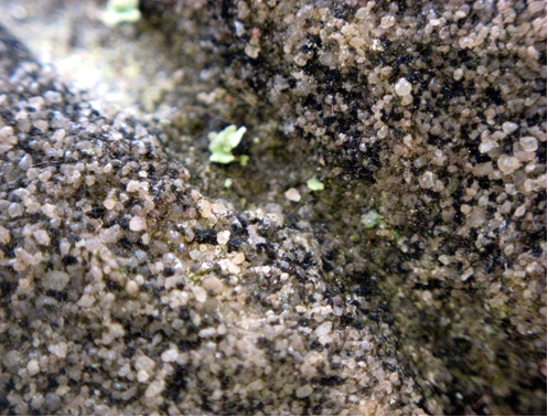
The rock is reddish-orange quartz arenite sandstone comprised of relatively fine-grained, well sorted and well-rounded quartz particles. The rock exhibits parting along laminar planes that likely represent bedding and has an up to 2mm thick weathering rind characterized by hematite coated grains that partly cement the quartz sand grains.
The rock is dominantly grain supported and poorly cemented by clay, hematite and syntaxial quartz overgrowths. The sample is very permeable with porosity of approximately 25%. A few areas of low porosity were observed with sutured grain boundaries suggesting low grade metamorphism.
MINERALOGY: OPTICAL PROPERTIES:
MINERALS VOL%* COLOR BIREFRINGENCE RELIEF OTHER
quartz 96-100 colorless low 1st order low dominant lithology
chert trace colorless to light brown low 1st order low
clay 2-4 light yellow to brown 1st to 2nd order low as cement
hematite trace red to red-brown or opaque masked low to medium as cement
* Based on visual estimation of thin section
Portable Microscopic Examinations
Numerous microscopic photographs were collected from the Du Luth boulder inscription and from man-made surfaces on three dated monuments comprised of Hinckley Sandstone. The focus was to document various aspects of weathering of the monuments to compare with the Du Luth boulder.
The 2008 monument exhibited sharp, well-defined boundaries along the inscribed characters with no color change due to oxidation of hematite cement. Little erosion of surficial clay and hematite cement between quartz sand grains was observed. Loss of cross-sectional area due to weathering along the carved characters was not detected.
The two sandstone monuments erected in 1927 exhibited a noticeable, yet relatively minor loss of clay and hematite cement between surficial quartz sand grains due to weathering.
The Du Luth boulder exhibited significant erosion of clay and hematite cement between surficial quartz sand grains that mimicked the glacially weathered surfaces of the boulder. The carved lines exhibited significant rounding of edges consistent with lengthy exposure to weathering.
A silica cemented dikelet bisected the boulder creating a ridge roughly 3/16” taller than the rest of the rock. This represents approximately 10-12,000 years of weathering since the boulder was deposited by the glacier giving a fixed data point for weathering.
Findings of Fact
1. The boulder is located roughly 7 miles east of Askov, Minnesota, in a relatively remote wooded area with a latitude/longitude of N 46 11.629, W 92 39.810.
2. The long axis of the boulder is aligned almost due east-west.
3. The inscription was carved into a glacial erratic boulder comprised of Hinckley Sandstone with dimensions of approximately 55" x 42" x 30."
4. The inscription carved into the boulder reads, “. 1679: Du Luth.”
5. The average height of the carved numbers in the date is approximately 3 1/4 inches, and the average height of the letter in the name is approximately 2 inches.
6. The inscription was reportedly first discovered by then landowner Nick Warabel, who was hunting and noticed the man-made carvings sometime between 1964 and 1967. He cleaned off the moss with his fingers and a hunting knife.
7. After being destroyed by the Hinckley fire in 1894, the village of Askov, Minnesota, was founded in 1906.
8. The inscribed boulder is situated along the north-south continental divide between the Great Lakes and Mississippi watersheds.
9. According to French-Canadian historian Gilles Durocher, the numbers and block-style letters are consistent with the pre-1860s French style.
10. The spelling of the French explorer’s name on the boulder, “Du Luth,” is consistent with one of the multiple known ways the explorer's name was spelled.
11. The historical record in Montreal reports that explorer Daniel Greysolon Du Luth was in the area of Minnesota in 1679.
12. The presence of two punch-style dots proximate to the inscription is consistent with other Renaissance era North American explorers such as Columbus.
13. The edges of the carved numbers and characters are significantly rounded from weathering for an unknown period of years.
14. The weathering of the man-made grooves with exposed quartz sand grains had essentially the same appearance as the glacial-age surfaces of the boulder.
15. The siliceous dikelet running through the boulder produced a 3/16” high ridge from approximately 10-12,000 years of weathering of the adjacent sandstone.
16. The weathering observed on the two monuments made of Hinckley Sandstone, erected in 1927, was significantly less advanced than the Du Luth inscription.
Interpretations
Based on our field and laboratory work, the following interpretations are appropriate:
1. The inscription was carved into a glacial erratic boulder that was likely transported from a nearby bedrock source.
2. The weathering of the Du Luth inscription is more advanced than the two sandstone monuments examined suggesting the carving is older than 1927.
3. The date inscribed on the boulder (1679) is consistent with historical accounts of Du Luth’s exploration into the Lake Superior region.
4. Since the inscribed boulder is located along the continental divide between the Great Lakes and Mississippi watersheds, it appears likely the explorer intended to mark and possibly claim the land at that specific geographic location.
Conclusion
The preponderance of the geological, historical, and geographical evidence is consistent with the Du Luth boulder having been carved by the Daniel Greysolon Sieur Du Luth exploration party at the date stated in the inscription.
Recommendations
It would seem appropriate that an archaeological investigation be conducted in the immediate vicinity of the boulder in an attempt to recover any additional artifacts that might broaden the historical context of the site. Further, it would also be helpful to obtain additional microphotographs from other dated Hinckley Sandstone examples.
References
Blegen, Theodore, Minnesota: A History of the State, Second Edition, University of Minnesota, 1963, 1975.
Matsch, Charles L. and Dr. Richard Ojakangas, Minnesota’s Geology, Univ. of Minnesota Press 1982.
Neill, Edward D., The History of the Upper Mississippi Valley, Minnesota Historical Company, 1881.
Wisconsin Historical Society, Memoir of Duluth on the Sioux Country by Daniel Greysolon Duluth, Document No. AJ-054, 1678-1682.

The inscribed boulder is a glacial erratic comprised of Hinckley Sandstone and includes the year "1679" and name "Du Luth."


Two round dots appear to have been carved to the upper left of the number "1" (top) and to the lower right of the first "U" (bottom).
A close-up view of the groove in the number "1" shows significant rounding of the carved line and significant loss of the clay cement between sand grains consistent with advanced weathering (15X).

A closer view of the wall of an inscribed groove (330 years old?). The black and green colored lichen hastens the weathering of clay cement between sand grains (60X).

A close-up view of a glacial aged surface (10-12,000 years old) shows a similar weathering profile with the same loss of the clay cement between sand grains (15X).

A closer view of the glacial aged surface (12-15,000 years old) with the loss of clay cement between sand grains. The black particles and green colored material between sand grains is lichen (60X).
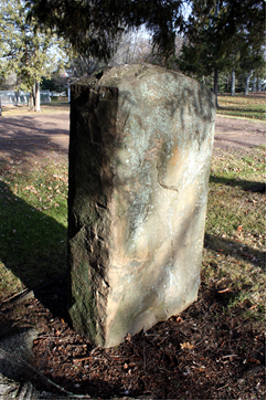

The Dr. P. N. Fenger monument in the Askov City Park is comprised of Hinckley Sandstone and having been erected in 1927 serves as an excellent weathering control sample. The drill holes present on the sides indicate a man-made surface.

A close-up view of the Fenger monument surface (87 years old) shows a less advanced weathering profile with a lesser amount of the loss of the clay cement between sand grains (15X).

A closer view of the Fenger monument surface (87 years old) shows a lesser amount of the loss of clay cement between sand grains. The small black particles between sand grains are lichen (60X).

The Christian Everson monument in the Askov Cemetery is comprised of Hinckley Sandstone and having been erected in 1927 serves as a second excellent weathering control sample.
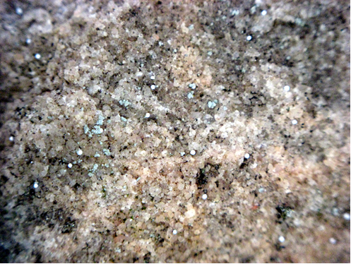
A close-up view of the Everson monument surface (87 years old) shows a less advanced weathering profile with a lesser amount of the loss of the clay cement between sand grains (15X).

A closer view of the Everson monument surface (87 years old) shows a lesser amount of the loss of clay cement between sand grains. The small black and light green particles are lichen (60X).

The Kenneth Bresin monument in the Askov Cemetery is comprised of Hinckley Sandstone and having been erected in 2008 serves as a modern weathering control sample.

A close-up view of the Bresin monument surface (1 year old) shows virtually no discernable weathering or loss of the clay cement between sand grains (15X).

A closer view of the Bresin monument surface (1 year old) shows no discernable loss of clay cement between sand grains. No black or light green colored lichen particles are visible (60X).

A closer view of carved groove of the Bresin monument exhibits a sharp and defined edge after one year of weathering (60X).

Side view of Hinckley Sandstone hand sample collected at Du Luth Stone site.

Top view of Hinckley Sandstone hand sample collected at Du Luth Stone site.
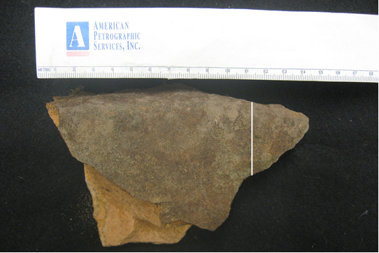
White line indicates approximate location where thin section was cut from the hand sample.

Dark reddish-black hematite cement was observed coating mostly sub to well-rounded quartz sand grains up to approximately 2 mm depth from the outer surface. Photograph taken under plane-polarized light (40X).

Abundant hematite cement was observed proximate to outer surface. See next image for zoom of red rectangle. Photograph taken under plane-polarized light (40X).
Reddish-brown hematite comprises bulk of cement between quartz sand grains. Photograph taken under plane-polarized light (200X).

Red arrows indicate clay cement in sandstone. Photograph taken under cross-polarized light (200X).

Numerous quartz grains with syntaxial overgrowths which also serve as a cementing agent. Photograph taken under cross-polarized light (100X).
Congratulations, Scott. I enjoy your work. I have been watching recently “Secrets of the Viking Stone” on Discovery+ and have taken a real interest in the story. Have there been any public debates between yourself and Hendrik Williams? I think a lecture tour would be fabulous with you two and very informative…. Or a debate with Dr Jackson Crawford..? Who knew a battle between Geology and Linguistics could be so fascinating!
ReplyDeleteThank you, but it's only a beginning. There are so many more important artifacts that have yet to be acknowledged beginning with the most obvious and important, the Kensington Rune Stone.
DeleteHenrik WIlliams would never accept a debate with me. He knows I know too much and about his unethical behavior. Frankly, I'd tie him up in knots and he'd storm off. He won't do it. Anybody else who wants to try, let's do it!
Bout dang time!
ReplyDeleteTrue that... Let's hope this is just the beginning. I'm very cautiously optimistic.
DeleteScott,
ReplyDeleteI have analyzed the four 1179 CLY maps. Contact me if you would like to discuss the place numbering system used in those maps and possibly continued in Map 8 Part 2. I believe I understand Ralph de Sudeley's route from July 1178 to the latter part of 1179.
Dr. Bobby,
DeleteIf you are referring to the numbers 1-6 on the Nova Scotia map, you should know we have two pages of notes that correspond to those numbers Don and I have not published yet.
There is important information in those notes that includes comments about the stops and events that occurred along the way during De Sudeley's voyage (1177-1180). We will be publishing all of that material, and much more, very soon.
Scott,
ReplyDeleteI am referring to the numbers 1-32 (with some missing values) in the CLY Maps 1-4 and the Neck Map. It does seem likely, as you wrote, that in these maps CLY = Clyphus Lucinus Yzerbo “I” (i.e., the “first” person by that name, with possibly CLY “17” being the descendant person in 1663).
I believe these numbers label sequential campsites. Furthermore, I believe these numbers represent elapsed weeks since the 1178 Expedition departed L’Anse aux Meadows circa July 25, 1178. That was “time zero” on the CLY Maps. Basically, the numbers represent the elapsed weeks after departing L’Anse aux Meadows until that numbered campsite was reached and its coordinates were determined by “sky bearings”. In CLY Maps 1-4 each numbered campsite has its coordinates listed (and none of the campsite numbers are duplicated therein). However, the Neck Map contains four “numbered sites” but possibly just one set of coordinates (which you have blacked out). So, it’s unknown to me if that set of coordinates is different from what is listed for Oak Island in CLY Map 1 (which site, by the way, is unnumbered).
Ralph de Sudeley (RdS) said there were six ships and 140 persons in the 1178 expedition which left Denmark. After Week 6, it appears the expedition split into at least two or possibly three separate forces, each with a separate mission, and each with a complement of men and ships.
RdS took only two ships and 2-3 dozen people with him to try to recover scrolls at Hunter Mountain in New York. That leaves four ships and at least 100 people to do other things.
RdS says two ships were to take back oak trees (presumably for Valdemar’s shipyards in Denmark), but we don’t know when they departed. Those two ships and crews might have departed shortly after “Week 5” in 1178, or they could have remained until the other two ships and men (also not a part of the RDS force) had completed their special mission, returning to Europe together.
Therefore, over 100 crew and 4 ships were available for two other missions besides the Hunter Mountain scroll recovery. One non-Templar mission was to bring oak logs back to Denmark (requiring two ships and a sailing crew). That left at least two ships and perhaps 60-80 men for the third mission for an unstated purpose. I believe that third mission was a Templar project to deposit religious and historical artifacts they had recovered circa 1110 in Jerusalem and had subsequently transported to Italy. There also appear to have been numerous later voyages beginning in the fourteenth century to move Templar treasures from Scotland to North America. My focus here is on that first 1178 voyage, long before the Templars were disbanded in 1307, and long before Templar Scots later moved treasures from Scotland to North America (in 1395, 1398, etc.).
I believe 2-4 ships and at least half the total crew stayed behind and completed the other Templar mission. This second (larger) expedition was split from RdS’ force, probably staying at Oak Island circa Week 6 until their monumental task was completed and they could return to Europe (in the summer of 1181).
In Maps 1-4 the locations were said by RdS to be based on “sky bearings” taken by Altomara. Apparently Clyphus recorded her latitude and longitude measurements on his maps, up to his death by a lightning strike on Hunter Mountain not long after Week 30. So, it is possible that none of the sky bearings on the Clyphus maps were done by Clyphus, although he probably recorded Altomara’a measurements.
Subsequently, after Clyphus’ death when RdS departed Hunter Mountain and returned to Long Island, we have just the two crude sketches of the Hudson River Valley and Long Island. These were presumably made by some member of the RdS Expedition, but not by Altomara or Clyphus, who were both deceased at that time. Accordingly, those sketches have no coordinates, apparently because both “navigators” with RdS were dead.
[End of Part 1]
Scott,
ReplyDeleteHere is Part 2:
To summarize, CLY "Map 1" (of Newfoundland and Nova Scotia) dated 1179 shows locations for campsites at Weeks 1,2,3, 4, 5, and 6. These locations refer to Weeks 1-6 after departing L’Anse aux Meadows. They appear to be “island shopping” in Newfoundland at what became to be called St John’s Island (now Prince Edward island). So, we have another indication already (besides the date match between the RdS narrative and the CLY map date) that the Templars were involved in Clyphus’Map 1. That notion is cemented by the fact that there is only one specific date listed on all these maps – June 24th, which is St. John’s Day (and which is celebrated in many ways by Templars and Freemasons).
CLY "Map 2" of Massachusetts shows campsites in Weeks 7 and 8. This map was not created until sometime later, being dated as Week 29 (during RdS’ winter layover in Newport).
CLY "Map 3" (of Rhode Island, Connecticut, New York, and Long Island) which is dated as Week 31 shows the campsites for Weeks 9, 10, 11, 12, and 13.
CLY "Map 4" (which is undated) shows the campsites for Weeks 21, 22, 23, and 30.
All these maps include latitude and longitude estimates for each campsite.
I believe the RdS force rendezvoused with his one remaining ship near the east end of Long island in Week 13. Then the combined party spent the winter anchored in Narragansett Bay and encamped near Newport Tower site. Note that campsites 21, 22, and 23, are VERY close to the Tower. The next campsite is Week 30, to the north up the Taunton River (and past the Anosett River mouth where the Native peoples' legend, recorded in 1680, tells of a wooden house with foreigners which swam up the Anosett River).
I believe the RdS force spent the winter from soon after Week 13 to just before Week 30 at present-day Newport (i.e., roughly October through January). That implies an opportunity for the nearby rune stone to be carved at Narragansett, although perhaps this was done previously by Vikings on an earlier visit than in 1178-1179. I suspect the Vikings already knew of the favorable anchorage at Newport prior to 1178.
The Clyphus Maps imply RdS went to Hunter Mountain in Week 12, but then quickly returned to the coast by Week 13, rendezvousing at Long Island with the single remaining ship (one had previously sunk near Nova Scotia). Then RdS spent the winter at Newport Tower, before moving North to campsite 30 and then West to reach Hunter Mountain again. Surely some weeks were spent there exploring the caves and recovering scrolls as described by RdS.
When RdS reached Long Island again some months after Week 30, it appears his one remaining ship was not there (although RdS does not mention this). This event forced his crew to construct a craft for the return voyage. Why his last ship was not there is unknown. It seems unlikely RdS would have been left purposefully, so perhaps the ship and men were lost at sea or attacked by natives. In any case, RdS’ ship construction and return voyage seem miraculous. However, I would think the Viking crew provided by Valdemar probably had shipbuilding and repair experience, and it is possible what RdS says here is true, as remarkable as it seems.
[End of Part 2]
Scott,
ReplyDeleteHere is part 3:
Turning now to the unsigned and undated Neck Map (labelled Map 8 Part 2), we see it has numbers for campsites in Weeks 5, 6, 7, 8, 9, 25, and 32. Interestingly, "huit" (8) is shown in two different locations, one of which is obscure. The inclusion of Weeks 5-32 implies two things: (a) this map was not made by Clyphus, since he was located elsewhere with RdS, and (b) it is a record associated with a different mission than Hunter Mountain. In fact, we don’t know if this map records any activity circa 1178, and the handwriting in it is different than in the other maps. It does indicate a deposit in 1395 for #7 and #9 on Oak Island, with a subsequent recovery in 1769. The inclusion of an extra “C” in the recovery date is strange. Possibly this is a transcription error. It appears that the maps are all copies made long ever the events depicted. In any case, the 1769 interpretation of the recovery date matches the John Weems, Jr. journal entry, so it seems likely that 1769 date is correct. 1769 is also quite consistent with the Money Pit story, in which three young men find the subsided filled-in pit and block and tackle. Clearly, whatever was buried in the Money Pit was recovered not very long before 1795. No rational person burying something in the Money Pit would leave a block and tackle dangling from an oak tree limb over the pit. That is a sure sign that whatever was buried there was removed. That being said, it is possible that the burial sites used in 1395 correspond to stone features first emplaced on Oak Island circa 1179.
I believe Templars on the “Third Mission” in 1178-1181 buried Jerusalem artifacts elsewhere on Oak Island. There is a great deal of independent evidence for this. In fact, there are four methods by which the initial (1179) Burial Vault may be located today. It is not at the Money Pit.
From late summer in 1178 to very late in 1180, the “Third Mission” group constructed a huge star map on Oak Island using large boulders and stone cairns. It covers the entire sky and the whole island. So far, I have identified about 66 stones which were aligned to rising and setting stars (and sometimes to other stone pairs) with an accuracy of a small fraction of a degree! About twenty constellations are represented As an archeoastronomer, I can model the Earth’s precession and determine the date(s) when these star alignments were done. That result is 1180 +/- 12 (at 2 sigma or 95% probability). The close match between the archeoastronomical date and the RdS narrative date demonstrates the stone/star map (which I call Stella Fanum) was constructed on Oak island concurrently with the RdS narrative (or at least within a few years of that time)
Interestingly, one small and well-known stone feature on Oak Island was modified and aligned many centuries later.
Scott,
ReplyDeleteIf stellar (not solar) sight lines can be identified in the Newport Tower, it may be possible to determine a rather precise date of construction. My guess is that much of it was built by the RdS force while they spent months at that site during the winter of 1178-1179 (they had idle time and some of the men may have needed “busy work”). The astronomical alignments thought to be present imply one of its primary functions was as an observatory. It also clearly implicates the Templars as the designers rather than Vikings. The precision of the dating depends on how many stars were used, on where those stars are located in the celestial sphere, and on the construction accuracy of the star sighting ports. A reliable date can be obtained with as few as three separate star alignments. Do these exist? On Oak island, all the star alignments are done about 2 degrees above the horizon at first/last star sightings. Star identification sightings can in principle be done at any elevation angle. Some might be on the meridian, looking due south or north. It is not possible to date the solar alignments.
If anyone has the elevation and azimuth of sight lines between pairs of “ports” (or other types of sighting markers) in the Newport Tower, I can search for possible star targets whose alignments are datable.
Dr. Bobby,
DeleteThis is quite the tome and it's obvious you've read our Oak Island book and perhaps others. If not, you should get Don's book, "Scrolls of Onteora" and my "Cryptic Code of the Templar's in America." That will give you everything we have published so far.
One thing I can tell you is the numbers on the maps are not campsites. The information is very specific about activities that occurred at those locations. That said, they could have camped at some of the locations but that was not the primary purpose of the numbering.
The Newport Tower is primarily an observatory as well as marking a settlement/land claim. According to the notes, the laying out of the alignments began in 1368 with construction completed by the Templars circa 1400. This was about the time activities began on the Underground Project on Oak Island.
Is there any record of a trip to Runestone island in the year of 1110? There are four men from Norway and five females from Germany that are buried on the hill that was an island back then.
ReplyDeleteIf you mean Rune Stone Hill at the Ohman farm, then no. The Kensington party was there in 1362 and if you're referring to the "10 men red from blood and death" in the inscription, then no. The 10 men references are allegorical, not literal.
DeleteI hope that answers your questions.
Scott,
ReplyDeleteEvery numbered location plotted in CLYs 1179 Maps 1-4 has latitude and longitude coordinates listed. In that era and place, determining latitude and longitude required taking two “sky bearings” using bright stars. This was necessarily done at night and required several hours to complete, and occasionally maybe several days waiting for clouds to clear. I would expect the Ralph de Sudeley (RdS) Expedition to remain at the observation site so the “navigator” would be well protected and there was no chance the party would be split up which would increase the risk of an attack by natives.
Taking "sky bearings" required Altomara and/or CLY (Clyphus) [the two “navigators”] to make two measurements. First, to find the site longitude, they had to measure the Magnetic Variation. We know they had a good compass for two reasons. First, the magnetic variation for Oak island is listed in the Stephenson and McGinnis Cryptograms. This is, in fact, the oldest known recorded magnetic variation measurement (by more than three centuries!). Second, on the trip across the Atlantic, the Vikings changed course in the middle of the Atlantic when the Magnetic Variation became zero. So, the Vikings in 1178 could measure the magnetic variation even in a ship at sea.
With a clear sky, true North and true South may be determined by measuring the magnetic bearings of a sunrise and sunset on the same day. This can be done accurately at sea with clear horizons if you have a magnetic compass with a 0-360 degree bearing scale and an alidade (a rotatable sighting arm with two peepholes). You turn the compass case so the compass needle is at 0/360 degrees (which is now Magnetic North). Then the alidade is turned to view the target (sun or star). Then you just have the read the bearing of the alidade on the compass bearing scale, which is the magnetic bearing of the target. It does not matter if one uses the first visible part of the solar disk or, say, when the entire disk is visible above the horizon, so long as the same method is used for both sunrise and sunset. True North and True South may then be calculated as the midpoints between the sunrise/sunset magnetic bearings. The Magnetic Variation is then simply minus the northern midpoint value (or 180 degrees minus the southern midpoint value). When Magnetic North is east of True North, the Magnetic Variation is positive, and it is negative when the compass points west of True North.
Measuring Magnetic Declination at night using stars is more difficult and generally less accurate than using sunrise/sunset bearings. For that reason, I suspect that the sunrise/sunset bearing method was preferred on land as well as on sea, but this would require a hilltop or high promontory to render tree blockage a negligible error at the two sighting directions.
To find True North at night, there are two possible methods. One method uses a star-rise and star-set instead of sunrise and sunset. In this case one simply measures the magnetic bearings at the points of first and last visibility of the same star (which will typically be at about 2 degrees above the horizon).
[End of Part 1]
Scott,
ReplyDelete[Start of part 2]
Alternatively, and more easily done, the second method is to measure the magnetic bearings of the star when it is at the same low altitude. For example, one could set the cross-staff to 5 or 10 degrees altitude. Then one measures the magnetic bearing of the star when it rises to 5 degrees, followed by a similar measurement when it sets at 5 degrees altitude. The advantage of this method is that it does not depend on the sensitivity or stability of the observer’s eyesight. In addition, bright stars are easily seen rising up through 5 degrees altitude, so there is no surprise in visibility as occurs when the star is first sighted at the limiting visual magnitude. Even thin clouds or fog won’t render the second method inaccurate, but they would make the first method erroneous. So, I expect the second method of star sightings at a fixed altitude of 5-10 degrees to be more accurate, to be doable in less than perfect atmospheric clarity and with less than perfect eyesight, and therefore more likely to have been used.
Once the Magnetic Variation is known, the longitude may be calculated as a constant plus a scale factor times the Magnetic Variation (MV). A good approximation which could have been used across the North Atlantic in 1590 (the first year in which there is a large-scale map of magnetic variation) is Longitude = -30.7 + 2.533*MV. This formula has a RMS error of about 1 degree. I note that since the 16th century, the Earth’s magnetic pole has begun to shift rapidly, and a simple linear equation like this is no longer accurate. Even in 1590 it was only accurate in western Europe across the Atlantic Ocean to eastern Acadia.
Measuring latitude is conveniently done at nighttime if one has a table of bright star declinations. Repeated measurements are made of the altitude of a selected star (preferably not too high above the horizon as it crosses the N-S meridian. Being low in the sky optimizes the accuracy of measuring the star’s altitude. One needs to be 5-10 degrees above the horizon to avoid significant refraction error and to increase the apparent magnitude of the star, making it easier to sight accurately with an astrolabe or cross-staff. These star altitude measurements can be done either near the South horizon or the North horizon. Having ten or more known star declinations allows one to find the site latitude without waiting for long periods for a star to cross the meridian. The RdS narrative mentions that Clyphus had such a star table.
The star altitude is measured with a cross-staff or an astrolabe as it crosses the meridian from east to west in the southern sky (or from west to east below the North Celestial Pole). The extreme altitude value is then selected (which is the maximum for southern viewing and the minimum for views to the North below the North Celestial Pole, or NCP). The extreme value occurs when the star crosses the meridian. Then the latitude of stars viewed to the south is simply 90 degrees minus the observed maximum altitude (on the meridian) plus the star’s known declination. For stars viewed under the NCP, the site latitude is the observed altitude – 90 degrees plus the star’s declination.
If one had a table of the solar declination for each day of the year, one could simply measure the Sun’s altitude across local noon to get the site latitude. That is what was done in more recent times when the sextant was invented. It’s possible such a table (an almanac) existed circa 1178 based on prior measurements in Europe. Such a solar almanac would be useful, too, in that if one knew the latitude and the season of the year one could estimate the date.
[End of Part 2]
Scott,
ReplyDelete[Start of Part 3]
To summarize, finding latitude requires a table of bright star declinations and an angle measuring device such as a cross-staff or astrolabe. The cross-staff is preferable since it is adjusted while simultaneously viewing the star and the horizon (which is possible even if there is some boat motion), and the angle reading can be done leisurely afterwards by the same person. Finding True North and the magnetic bearing of true North requires a compass and two observations by one person (when the target rises and sets). In this era and for the extent of this voyage, the longitude may be estimated with reasonably good accuracy from the measured Magnetic Variation.
Finding longitude requires a magnetic compass with an alidade to sight the target near the horizon. This can be used both day and night, so long as the star/Sun are simultaneously visible.
In my opinion, it is highly likely that the Expedition camped at the observation site while the nighttime sky bearings were taken. That makes each numbered site a campsite, as I said previously.
We also know the “numbers” used to label the sites generally increase monotonically consistent with the travel descriptions in the Expedition’s narrative written by RdS. That is, the sequence of sites generally matches the sequence of events and the described locations in the narrative. Furthermore, letting each number indicate the number of weeks since the expedition departed L’Anse aux Meadows is consistent with the Expedition’s arrival in Newfoundland about August 1, 1178 (by the Gregorian Calendar) and an arrival in Europe in the late summer or early fall of 1179. It then took until very early in 1180 for RdS to reach Seborga, Italy, when his report to the Templar Grand Master was recorded.
If, some centuries later, CLY’s descendants collected and prepared two additional pages of notes regarding these maps, that would be a highly useful supplement to the maps themselves. I would expect those notes will answer some and add more questions. The notes may identify additional activities (such as deposits and recoveries) carried out at the numbered sites. In summary, the numbered sites tell us the time sequence of stops along the route and the relative dates of each “sky bearing” site. The fact that there are missing numbers implies the numbers represent elapsed time (since some stays lasted more than a week at the same site). I would expect a simple listing of tasks/deposits to be consecutive with no missing values.
I would expect that the Scottish voyages in the 14th century may have visited some of the same sites as RdS visited besides Oak Island (and perhaps these are shown in the unpublished parts of Map 8). What I hope to find is a map of the travels of the much larger group of Templars and Vikings which did not go to Hunter Mountain but stayed and worked on Oak Island from 1178-1181. I believe they made the only deposit there that has not been recovered.
Dr. Bobby,
DeleteThe work on Oak Island the tradition called "The Underground Project", began in 1395 and is detailed in Don and my latest book. You can get a signed copy here if so inclined, https://scottfwolter.com/product/oak-island-knights-templar-and-the-holy-grail-secrets-of-the-underground-project-revealed-the-hooked-x/
The documents also relay that the treasures on Oak Island were recovered in 1769. This has been verified by 12 seasons of nothing on the Curse of Oak Island show.
Your knowledge of navigation is quite impressive, and you can be sure the Templars were just as versed in celestial navigation going back to their beginnings. It was one of their most important secrets that helped their rise to wealth and power.
There is a LOT more to come regarding the SInclair/Wemyss journals and the Cremona Document material. Stay tuned!
Scott,
ReplyDeleteI have no reason to doubt that deposits of valuables made by Scottish Templars on Oak Island in and after 1395 were subsequently recovered. They were items of monetary value and were used according to a long term plan to fund the Templars’ expansion into America.
However, I contend that a group of Templars and Danish sailors made the first deposit on Oak Island long before then, in 1178-1181. I also believe that first Templar deposit has not been recovered. In fact, it was intended to be a time capsule, not a safe deposit box. The contents were religious and scientific artifacts (the “wisdom of the ages”) which the Templars recovered under Solomon’s Temple in Jerusalem circa 1118.
Taking the Cremona Document at face value (which I do), here is a summary of its relevant information:
1. In 1178 Templars and Vikings sailed to Newfoundland, Nova Scotia, and New England, starting with 140 men and six ships.
2. After his return to Castrum Sepulchri in Italy in early 1180, Ralph de Sudeley (RdS) dictated a detailed account of how several dozen men and two ships under his command made their way to Hunter Mountain and back.
3. RdS does not describe what the other 100+ men and four ships did in the meantime, although he does say that Hubert would return with the disks, and two ships would return with wood to the Danish King Valdemar I.
4. Hubert failed to return, but RdS does not say what the majority of the original expedition force did after they arrived, or whether they returned.
I contend the majority of the people and ships in the 1178 expedition completed a second Templar mission – the creation of a “New Temple Mount” in the New World. The labor expended in this construction (which I call Stella Fanum) on Oak Island was roughly 100 man years. Considering the time and place, it was an immense project involving a huge amount of manual labor. That group also returned to Italy with detailed information on the construction and on the deposit location.
The fruits of their labor are still evident over virtually the entirety of Oak Island. They built precise star maps on the ground with 60+ identifiable stone features, such as huge, emplaced boulders and excavated and stacked stone cairns, some of which are 12-20 feet in diameter.
Because many constructed stone features were precisely aligned with rising and setting stars, archeoastronomical dating is possible with extraordinary accuracy. My derived date is 1180 +/- 12 AD (at 95% probability). This date is consistent with the 1178 expedition described by RdS and supports the idea that most of the people stayed at Oak island and built Stella Fanum while RdS and a small contingent went to Hunter Mountain to recover scrolls.
[End of Part 1]
Scott,
ReplyDelete[Part 2]
I also make the following points:
1. None of the items recovered by the Templars in the Temple Mount circa 1118 have been found or even written about subsequent to 1180.
2. I predict (and assume) that none of the Temple items are listed in the unpublished Sinclair/Wemyss Journals or in Map 8.
3. It is quite possible, and perhaps even likely, that Scottish deposits in the 14th and 15th century on Oak Island took advantage of the 12th century Templar constructions to mark their locations.
4. One of these later deposits (perhaps “sept” or “neuf” in Map 8 part 2) could have been buried at the Money Pit, the site of the stone feature in Stella Fanum replicating the star Diphda.
5. If that Scottish deposit were recovered by John Weems, Jr. in 1769, that would explain the sunken area and block and tackle found by McInnis in 1795 at what is now called the “Money Pit”.
6. The 1180 “New Temple Mount Deposit” is locatable by multiple methods, including the La Formule and Stephenson cryptograms, the clever star puzzle created by the design of the star maps in Stella Fanum, crossing lines of sight using pairs of stones, and a 19th century map.
7. The four methods of locating the New Temple Mount Deposit provide a consistent and precise location which has not been excavated.
8. If one knows astronomy well, one can find the New Temple Mount Deposit with no technological aids by solving the star puzzle. That’s why I say it is a time capsule, not a safe deposit box. The intent in this case was to protect the artifacts until an enlightened age came about, not fund colonization.
Dr. Bobby,
DeleteYour thesis is actually supported by sound logic and reasonable speculation. However, the "Time capsule" aspect of the treasures was brought over in 1395 and 1398 under the care of Earl Henry Sinclair, and they were indeed recovered in 1769 and 1770. The Temple artifacts and remains were not kept in one location, and certainly not on Oak Island. The Templar tradition would never do something as silly as putting all their eggs in one basket. In fact, nothing of historic or symbolic value was hidden on Oak Island, just gold, silver and jewels that are now gone.
In any case, there is a detailed treasure list of the Temple artifacts and remains we are holding onto very tightly to but will publish in due time. Just know they are safe in various location in North America and will be revealed at the appropriate time.
I strongly suggest you get the Oak Island book is you haven't already. It will fill in some of the gaps in your knowledge base.
Keep up the good work.
Scott,
ReplyDeleteThe Scottish deposits in North America were made in multiple “safe deposit boxes” to which only a few insiders had maintained a “private key” over several centuries. These easily-monetized deposits were not intended to be found by an “outsider”, and therefore there was never a “public key”.
The 1180 Oak Island Deposit is quite different. It uniquely has a very public key (a long-lived star puzzle in plain view), implying it was intended to be recovered eventually by a person who was not an “insider”. A few high-level insiders also had a private key (a medieval cryptogram) as a backup should circumstances require this deposit to be moved again. We can infer that whatever was deposited at the solution of the cryptogram had not been recovered as of 1870 (when the cryptogram, now translated into modern English, was in Stephenson’s possession). Otherwise, if this deposit had been previously moved, why would a now-useless set of directions still be maintained in secret? In addition, there is no evidence for any removal in the post-1870 period, when multiple residents and searchers were present, and it would have been extremely difficult to completely hide such a recovery. Furthermore, no modern searchers are known to have excavated this site. Therefore, I conclude that whatever was buried on Oak Island in 1180 is probably still present.
The “public key” to the 1180 Deposit is large-scale star maps, within which the deposit is buried. Where else has anyone ever buried a “treasure” within the map itself, with the map being in plain view? Clearly, this is different kettle of fish than the later Scottish deposits.
I have read what you have published on Templar deposits in North America. So far, that does not include movements or current locations of the Temple artifacts.
I believe the Temple artifacts were buried on Oak Island in 1180. The “means”, “motive”, and “opportunity” are all present:
1. The archeoastronomical construction date of 1180 +/- 12 matches the Sudeley account of a voyage to North America beginning in 1178, on which there are about a hundred men and four ships whose activities were not accounted for. What was their “mission”? This 1178 voyage provides the “opportunity”.
2. The “motive” is also clearly indicated in the Aelia Capitolina portion of The Cremona Document detailing the recovery in the catacombs, especially that of bones they believed were John the Baptist, whom they revered.
3. The huge effort expended to build the “treasure map” extending about a kilometer over both drumlins on Oak Island must have been justified by a task of great importance, which is identified as a burial by the cryptogram. Thus, there are “means” for making the deposit (the use of many men and ships for a period of at least 27 months).
4. I am not aware of any documents indicating the Temple artifacts were hidden somewhere else after 1180.
You continue to ignore the purpose, and indeed, even the existence, of the huge star maps (i.e., Stella Fanum) built on Oak Island more than two centuries prior to the Sinclair voyages. That is understandable, since this is a fairly recent discovery I have made, and very little of this information is in the public domain. However, if one assumes the star maps exist as I have described, please explain the purpose of this immense and remote project, if not to mark the deposit in a New Temple Mount (the east drumlin of Oak island) of historical and holy relics such as the Templars recovered in Jerusalem circa 1118. I can’t think of any other purpose for such a large, risky, and time-consuming undertaking.
Dr. Bobby,
DeleteI have to be honest and say I think you’re being a bit pushy with your ideas and acting like you know more than we do. There is zero evidence the Templars were on Oak Island in 1180. That is purely your ‘star puzzle’ speculation I suspect is based on evidence presented on the Curse of Oak Island show. I would strongly suggest you take whatever evidence they present with deep skepticism, and I know for a fact they have planted evidence to keep the show going.
As far as what I have made public, it is a fraction of the information we have in hand which talks extensively about moving treasures and artifacts. We will make these documents public when the time is right. Frankly, you’re giving Oak Island way more credit than it deserves due largely to how much physical alteration has occurred on the island over the years. I was there in 2008, and it was a physical mess back then . You would be better served to focus on Newport, Rhode Island, or even Kensington, Minnesota than OI.
Stay tuned.
Scott,
ReplyDeleteI noticed a similarity of the “dotted cross” in Figure 259 in Don Ruh’s book on the scrolls of Onteora with Nolan’s Cross on Oak Island. I have recently identified two nearby stone features which may be related to the six known cones in Nolan’s Cross. That combination can produce a very similar shape to the eight-dot pattern seen in Jackson’s photograph. Maybe this is just a coincidence. I wonder what the 4” X 4” white square of paper could be? The back of a Polaroid? Maybe you could ask Don Ruh to try to identify that paper square and the long rod if he has the original Jackson photograph.
Dr. Bobby,
DeleteFigure 259 is on page 337 of Don’s book and is part of a “Zodiac Code” we deciphered in 2021. It turned out to be another passage from the Book of the Wars of the Lord. We will be publishing that passage very soon. To the best of our knowledge, there is no connection between this coded message and any stone features on Oak Island.
I’m confused as to what you mean by the “4” x 4” white square piece of paper?”
Scott,
ReplyDeleteThe photograph I am referring to is Figure 259 labelled “Jackson picture – I do not know what this is or what the key fits”. It is on page 334 in my copy of Ruh’s “Revised Edition”. Possibly other editions show different figure and page numbers.
The photograph shows four items on what may be the seat of an upholstered chair. One is a skeleton key. One is a blank letter-sized sheet of paper (presumably used as a background and to provide scale). One is a long metal rod, about ¼” in diameter and about 9” long. I think this is the rod removed from inside the Bannerman gate post ornament. It was attached to the ball, passed through the top of the ornament, and then had a pin on the bottom end. If I understand the ornament construction correctly, the ball, rod, and pin were effectively a key that allowed the top of the ornament to be removed. The fourth item is the white square with a pattern of eight dots on it. There are two dark lines on this white square. I can’t tell in the book image if these are drawn lines or possibly pieces of wire or maybe pins removed from the rod.
Dr. Bobby,
DeleteI found the picture; it's Figure 257 in my copy. I don't know what the key is for and suspect it was used as a "tell" for something else unrelated to the rod. I also don't know what the smaller piece of paper is with the Christian style cross in dots. The rod is likely part of the navigation device that came out of Altomara's tomb, but I don't know for sure. I'll find out from Don the next time I talk to him.
Far be it from me to be pedantic, but you spelled rune wrong in the second paragraph. ;-)
ReplyDeleteTru Leigh,
DeleteGood catch, I'll do better next time!
Yet you didn't correct it, like a pussy. You take anonymous posters who don't support you to task, but with anonymous posters who do support you it's "Come on in!"
DeletePussy.
Pussy,
DeleteYour comments are obvious, and you have the nerve to call me a disparaging name yet post anonymously.
If you're going to take me on, at least have the courage to use your real name. Otherwise, that makes you a pussy doesn't it?
Coward
These symbols are also on the show The Curse of Oak Island...I would love to see you on this show giving your input. Please go there as a visitor and introduce yourself. I think your knowledge would be very helpful to the mystery of Oak Island.
ReplyDeleteThe Curse of Oak Island is not a serious endeavor I'm sorry to say. The treasure that was once there was recovered in 1769. I've been invited to be on the show multiple times but respectfully declined due to credibility issues.
ReplyDeleteIn any case, enjoy the show as entertainment.
Scott,
ReplyDeleteRegarding Figure 259 labelled “Jackson picture – I do not know what this is or what the key fits”, which is on page 334 in Ruh’s “Revised Edition”, on February 24th you wrote: “ I'll find out from Don the next time I talk to him.” Have you asked him about these items?
So far, I have spent about six weeks trying to decipher the12 lines of ciphertext shown in Ruh’s Figure 261 “Translation of the symbols on the scroll”. This is the one with twelve 4-characters keys listed before 12 lines of ciphertext, each line being 69 characters long and preceded by a symbol of the zodiac.
Here is what I have found so far:
1. Based on the index of coincidence of the ciphertext, a substitution cipher was not used, and the language is English, and probably modern.
2. The cipher may use (columnar) transpositions, possibly done twice with the same key. Such transpositions do not modify the letter frequencies, which would explain why the ciphertext matches English letter frequencies.
3. The Germans used a double columnar transposition in WWI with an extra letter (usually a common one) inserted in between. This is called an Ubchi cipher. Without the key, this is very difficult to decipher.
4. There could be an extra letter in the ciphertext because there could be 17 rows of four columns (to match the key length) making 68 characters, plus one added character to make 69. Each of the twelve lines of ciphertext has 69 letters.
5. I don’t know if the zodiac signs represent a second key. If not, then why are they shown? If zodiac constellation names are a key, the shortest one is “LEO” which has only three characters, so possibly just the first three letters of each zodiac sign are used as a second key.
6. I have written a computer program which does a brute-force search among all possible solutions for a given pair of transpositions and an extra letter insertion.
7. I have tried 4/4, 4/3, and 3/4 key lengths, for all possible keys (of which there are 24 for 4 characters and 6 for 3 characters).
8. I have also tried all 4 character and 3 character keys using single transpositions.
9. I also tried reversing the ciphertext order.
10. So far, all I get is gibberish. That means the actual coding method is different from what I have assumed in my brute force solutions.
If you or Don are interested, you are invited to suggest other encoding methods which I could test using my computer program to search for meaningful plaintext. I get the impression there is a “missing step” which is necessary for the recipient to know in order to decipher these passages. Maybe you can guess what I am missing.
Hi Scott,
ReplyDeleteDid you hear about the huge slab of rock covered in over a hundred futhark caracters found near Wawa, Ontario?
https://www.popsci.com/science/runes-canada-stone/
Seems like Henrik Williams already took a look at it and the language ia legit.
Take care.
ÉTIENNE
ÉTIENNE, yes, I most certainly have heard of these carvings that are most interesting indeed! I reached out to the archaeologist in charge to try and make arrangements to examine the carvings.
DeleteI don't trust Henrik any farther than I can throw him, but at least he confirmed it's not a fake. He knows the Kensington Rune Stone is authentic as well. He just doesn't have the balls to stand up to his skeptical, and extremely arrogant academic colleagues.
I agree with you about Henrik Williams, I was just satisfied to see that in this situation even he could not argue against the language and its form. The explainations they have put forward to justify the presence of the Wawa inscription are improbable, I am not saying that the inscription is ancient or not, but the story about scandinavian workers having enough free time and knowledge to have carved it is laughable in my opinion. I truly hope you get to take a look at it eventually...
DeleteThanks.
Étienne
Étienne,
DeleteI will reserve final judgment on an interpretation until I see the inscription with my own eyes. The archaeologist in charge never got back to me which doesn't surprise me at all. I have been too busy to pursue this summer, but I will keep trying.
You can be sure I'll do a post when that happens.
Hey Scott when you get a chance go on YouTube and look for Sarah breskman cosmi. She does past life regressions and one she did was a client that had a past life as a knights Templar. And during session talks about hiding the treasure. Check it out
ReplyDeleteBruce
This comment has been removed by a blog administrator.
DeleteI saw that, too. It was a little vague, but it sounded like OI. Sarah claimed no knowledge of the search at the time. I read her book. Towards the end, one of her hypnotic subjects who claimed was an Atlantis refugee said they carved Hooked-X symbols all over the place, including what is now New England. I emailed this to Scott. I hope he checked it out.
ReplyDeleteHey guys, I know Sarah well and she shared the Templar past life regression experience with me a while ago. I trust her instincts and know the story of Templars hiding treasure in the America's is definitely true. Just read my latest book and you'll know it's true too.
DeleteScott-
ReplyDeleteOn Lake Mille Lacs the old Izatys Village ( Mdewakanton Dakota village} is on the same Latitude of the De Luthe Stone.
Izatys Village on Lake Mille Lacs
In 1679, Daniel Greysolon and Sieur duLuth visited Izatys.
Inscription.
In this vicinity stood the grand Sioux village of Izatys where Duluth planted the French arms on July 2, 1679.
The settlement was visited by Father Hennepin in 1680
https://www.forgottenminnesota.com/2021/01/15/izatys-village-on-lake-mille-lacs/
-----
Izatys
Vineland Historical Marker
https://www.hmdb.org/m.asp?m=19760
Mdewakanton Dakota village on Mille Lacs Lake on the south/western shore.
Marker. Location. N 46° 9.8′ W 93° 45.55′
De Luthe Stone N 46 11.629, W 92 39.810.
On the shore of Lake Mille Lac Just 1.24 Miles North of the marker is the modern name "Indian Point" on the same Latitude as the De Luthe Stone.
What is your opinion?
Scott-
Delete"southerly route"
In 1679, Sieur du Lhut followed established indigenous corridors to travel from Lake Superior to the Dakota villages at Mille Lacs. Based on historical interpretations and the recent discovery of the Du Luth Stone , his most likely "southerly route" can be traced as follows:
Du Lhut's 1679 Route
The route utilized a network of portages, rivers and trails.
Duluth (Little Portage) →
Du Lhut crossed Minnesota Point at the "Little Portage" on June 27, 1679, to enter the protected bay area.
Nemadji River →
He entered the Nemadji River (Superior, WI/Duluth area), which served as the primary gateway to the interior from the western end of the lake.
Upland Portage (Willow/Sand Watershed) →
Traveling south through the Nemadji watershed, his party used a portage ( 1-6 mile canoe carry) to cross the "height of land" near modern-day Askov/Bruno in Pine County.
Sand River (Sand Creek) →
From the upland site, the route descended into the Sand River (Sand Creek) headwaters,
Du Luth Stone →
At this strategic upland junction, he likely left the inscribed stone ("1679 DU LUTH") as a territorial marker or reference point.
St. Croix River →
He followed Sand Creek southward to its confluence with the St. Croix River.→
Mille Lacs (Izatys)
From the St. Croix, his party moved west through the Rum or Snake River watersheds to reach the Dakota village of Izatys on July 2, 1679.
Strategic Significance
Aazhoomog Hub: This route passed through the historic Aazhoomog ("crossroads") hub, where several major land and water trails intersected. The main village of the Aazhoomog was near the du Luthe stone.
Tactical Choice: Choosing the Sand River over the Kettle River avoided the dangerous "Hell's Gate" rapids, prioritizing safety for his party and their trade goods.
Hell's Gate is a notorious series of rapids and a sheer sandstone gorge on the Kettle River in Banning State Park (Pine County, MN). It is widely regarded as the most dangerous section of the river, with a reputation as a "widow maker" due to its turbulent whitewater, Glacial "Kettles" and high sandstone cliffs.
If his party had trade goods-he wouldn't want to loose them. Maybe he camped at the du Lhuthe stone location on the Sand River (Sand Creek)
Hello Scott:D,
ReplyDeleteExciting information you are providing to the public. I was wondering since the cistercian order was very active in Denmark during King Valdemars time, is there any connection to Denmark and Templars and the travels to America? I know we have some Vinland sagas back at home, and a huge fleet of ships at that time. Also nobles in Denmark friends with Bernhard Clairvoux.
Thank you in advance, keep pushing out this wonderful information, great work!
Hi Scott, great work, completely enlightened! Reading Cryptic Codes of The Knights Templar in America. My question would be : What movement is being made that would now incorporate women into Freemasons? Also would love a private conversation about the Mormon temple, Joseph Smith and Freemasonry. Since the sacred grove is so close to where you located Goddess mountain is it a possibility the golden plates are part of the freemasonry items left & could they have been mistranslated? I would like to become a Freemadon and Templar.
ReplyDeleteGlad to hear you enjoyed the book! If you are interested in Templarism and pursuing becoming a Templar, I suggest you search for: Templar Collegia.
DeleteLooks like you put a lot of effort into this post. It might be interesting but yiu lost me in the the second sentence with "mainstream archeology" but old habits die hard I guess. You first lost me with your nonsense about Sepent Mound in Ohio being linked to ancient Egypt and Scotland. But I almost gave you a second chance here.
ReplyDeleteAnother Coward,
DeleteFunny, you almost had me until you posted anonymously. It's not an "old habit", it's just truth and it sounds like it cut deep. I wonder why...?
I'll type slow you so can keep up. The connection is there are serpent mounds in both places. Got it?
Hi Scott:
ReplyDeleteI've noticed you've been in news a little more frequently lately, but this blog isn't updated very often.
Is there a better place on the web for me keep up to date on your latest news?
Thanks,
Steve K.
I suggest going to my website: scottfwolter.com
Delete